OpenRunner is an outdoor application developed in France for creating, planning and tracking sports activities, similar to Komoot.
I use the app to get the informative altitude profiles.
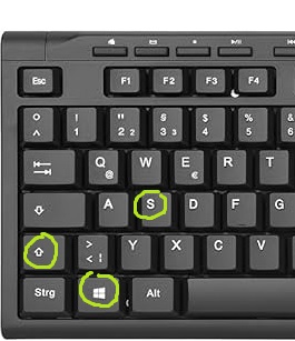
I save a screenshot of the altitude profile from Openrunner (practical cut key combination: windows key /shift and s), open the image with Paint and Paint 3D and label the image with POIs, i.e. information that is important to me.
(I search for the POIs with the Google, my maps app)
Registration on openrunner.com (free of charge) is required.
My step-by-step guide:
| 1 Click on Route Planner 2 Select Import |  | |
| 3 Add File |  | |
| 4 In Explorer, select the desired GPX file in the Explorer |  | |
| 5 Import |  | |
| 6 You can only see the altitude profileonly when the tour is saved. –> Save |  | |
| 7 Click on Activity 8 Choose your sport |  | |
| 9 Save |  | |
| 10 Display the route, Scroll down to the elevation profile |  |